August 17, 2023
Our oceans, covering over 70% of our planet, are facing unprecedented challenges. From increasing temperatures to rising pollution levels, marine biodiversity is at risk. Understanding these challenges requires us to delve into the intricate dynamics that govern marine ecosystems.
Documented human impacts on ecosystems are undeniable. However, fully gauging these impacts on marine ecosystems presents an intricate challenge due to their vast spatial scales and complex dynamics. Activities like fishing, dredging, and shipping are recognizable stressors, but quantifying their cumulative impacts, especially across varied time frames and spatial locations, demands a comprehensive approach. Assessing any entity’s detrimental influence on the marine environment mandates an integration of various data sources.
So, how can we predict and proactively address ocean health challenges in this intricate scenario?
Spatiotemporal technology offers a glimmer of hope. By analyzing data across both space and time, this technology paints a dynamic picture of our oceans’ health, allowing us to predict future challenges and devise strategies accordingly.
SeerAI emerges as a beacon in this domain. With their avant-garde tools, oceans’ secrets, previously veiled in vast datasets, are now revealed to researchers and policymakers.
The Geodesic Platform exemplifies this innovative drive. Inspired by the geodesic concept—minimizing distances between two points—it bridges the gap between posing critical questions and finding profound solutions.
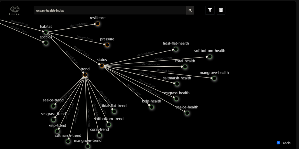
With the Geodesic Platform, disparate data sources intertwine seamlessly through a decentralized data mesh, allowing access to expansive datasets without the need for storage. This capability facilitates analyses on a planetary scale. Highlighting the platform’s prowess, we see its application in a recent analysis. Here, SeerAI repurposed an ocean health quantification model, merging it with additional data, to estimate individual ships’ impacts on marine biodiversity.
Integration of Diverse Data Sources: SeerAI’s Geodesic Platform fuses all data types to include satellite imagery, water quality indices, human activity, and marine species tracking, offering a comprehensive view of the marine ecosystem.
Advanced Algorithms for Real-Time Analysis: The platform provides instant analytics, identifying patterns and potential problem areas, allowing for proactive responses.
Scalability for Global Insights: With the ability to analyze data on a planetary scale, SeerAI can pinpoint both global and regional threats to marine biodiversity.
One of the most significant applications of SeerAI’s technology is in its predictive analytics. By understanding past and current data, the platform can forecast potential future changes in marine ecosystems.
Navigating the intricate waters of marine data requires tools that are both robust and intuitive. Enter SeerAI’s Geodesic Platform. Designed to efficiently handle and simplify the complexities of geospatial information, Geodesic stands as a beacon for those seeking to unravel the intricate tapestry of marine ecosystems.
By seamlessly integrating disparate datasets, Geodesic empowers users to access and analyze vast quantities of information without the constraints of storage. This, in turn, paves the way for unprecedented planetary-scale analyses, honing in on patterns and trends that were once hidden beneath the overwhelming wave of data.
But beyond its technical prowess, the true strength of the Geodesic Platform lies in its potential to spotlight critical marine biodiversity issues. In an era where decisive action is imperative, technologies like Geodesic play a pivotal role in equipping decision-makers, researchers, and policymakers with the insights they need. By illuminating these concerns, we’re not just observing them; we’re poised to tackle them head-on, harnessing the power of innovation for a healthier, more sustainable marine future.
In the challenging endeavor of marine biodiversity conservation, SeerAI is emerging as as a leader, offering cutting-edge spatiotemporal technology. With insights that not only illuminate the present state of our oceans but also light the way towards a more sustainable and biodiverse marine future, predicting ocean health becomes not just a possibility but a reality.